
In the fast-paced world of modern agriculture, staying ahead of the competition and maximizing productivity is crucial. One of the ways to achieve this is by leveraging the power of advanced farm mapping techniques. It, also known as precision agriculture, is a method that uses cutting-edge technology to collect detailed data about your land. This information can help improve farm management by enabling you to make more informed decisions and optimize your resources. In this blog post, we will delve into various aspects of this mapping, including different techniques, tools, and applications that can revolutionize your agricultural practices.
The Importance of Farm Mapping in Modern Agriculture
It plays a critical role in todays agriculture for several reasons. Firstly, it allows farmers to gain a deeper understanding of their land, including soil properties, topography, and plant health. This knowledge can lead to better decision-making and more efficient use of resources such as water, fertilizer, and pesticides.
Secondly, this mapping can help identify areas of the farm that require special attention, allowing farmers to address issues before they escalate. This proactive approach can save time and money by preventing crop loss and improving overall farm productivity.
Lastly, these mapping techniques can aid in environmental stewardship by minimizing waste and reducing the environmental impact of farming activities. By optimizing resource usage, farmers can contribute to a more sustainable future for agriculture.
Types of Farm Mapping Techniques and Their Applications
There are several techniques available, each with its unique advantages and applications:
Geographic Information Systems (GIS)
GIS is a powerful tool that combines spatial data with other relevant information, such as soil type, crop yield, and weather patterns. By integrating this data into a single platform, farmers can analyze and visualize their farm’s characteristics, leading to better decision-making and resource allocation.
Remote Sensing
Remote sensing involves collecting data from a distance, typically using satellite imagery or aerial photography. This technique can provide valuable information on crop health, soil moisture, and nutrient levels, allowing farmers to monitor their land’s condition and make timely interventions.
Global Positioning System (GPS)
GPS technology enables farmers to pinpoint their exact location on the farm, facilitating precise field measurements and accurate navigation. GPS can also be used in conjunction with other farm mappings tools, such as GIS and remote sensing, to enhance data accuracy and analysis.
Farm Mapping Tools: GPS, Drones, and Satellite Imagery
GPS Devices
GPS devices, such as handheld units or tractor-mounted systems, allow farmers to collect spatial data quickly and accurately. These devices can also be integrated with other farm equipment, enabling precision agriculture practices such as variable rate application of fertilizers and pesticides.
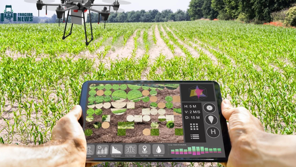
Drones
Drones, or unmanned aerial vehicles (UAVs), offer a flexible and cost-effective means of collecting high-resolution imagery of farmland. Equipped with advanced sensors and cameras, drones can capture detailed information on crop health, soil conditions, and irrigation patterns, providing valuable insights for farm management.
Satellite Imagery
It is a powerful tool for large-scale mapping of farming, offering extensive coverage and frequent updates. Farmers can access and analyze satellite data through various platforms, using the information to monitor crop growth, identify problem areas, and plan future land use.
The Benefits of Farm Mapping Software
Its software can help farmers make sense of the vast amounts of data collected through various techniques and tools. By integrating this information into a user-friendly platform, farmers can gain a comprehensive and accurate view of their land, which can be used to develop targeted strategies for improvement.
Some of the key benefits of using mapping software for farming include:
- Streamlined decision-making
- Time and cost savings
- Increased productivity
Conclusion:
By harnessing the power of farm mapping tools such as GPS, drones, and satellite imagery, farmers can collect and analyze detailed data about their land, leading to more informed decision-making and optimized resource usage. Embracing these cutting-edge technologies is essential for staying competitive in the modern agricultural landscape and ensuring a sustainable future for farming.


Comments